Preparing Devices
ArcGIS
The River Mile Network uses ArcGIS to collect and share data as it is the industry standard for natural resource agencies as well as many community planning organizations. ArcGIS features several platforms including desktop, online and mobile. There are many ways to work with ArcGIS. You do not need to be an expert in GIS or ArcGIS for desktop to use this tool. ArcGIS offers the ability to crowd source data collection and share that data immediately. It can be used for simple mapping to complex data analysis. Getting started is easy. Participate in one of The River Mile’s webinars to get started, then participate in in-person training to learn hands-on.
To learn more about how educators can utilize ArcGIS in the classroom and participate in training check out the US K12 GIS (arcgis.com) or GIS for Schools | Interactive Web Maps for K-12 Subject Matter (esri.com).
Download Survey123 App
Survey123 is a relatively new tool in the ArcGIS suite of mapping software and applications. The purpose of this technology capitalizes on the ease of access to GPS-capable smart devices. Survey123 is currently used by field researchers and land managers throughout the world to collect real-time data without the need for additional GPS equipment. Best of all, a data connection is not required; the app stores the collected data in the device until a WIFI connection can be reestablished.
Each group or team should have access to a smart device in the field. The Survey123 app is a free Esri™ product used to capture field data and upload the data to a cloud database. The Survey123 app must be downloaded to each smart device and will store survey data on the device until it can be uploaded to the database through an internet connection. An internet connection is required to initially download the Survey123 app and TRM survey forms. An internet connection is not required to gather data in the field.
NOTE: If you already have Survey123 loaded on your mobile device, make sure it is the most recent version. Older versions require sign in to download new survey forms. This is no longer required to participate in projects.
How to download the Survey123 app to a tablet or smartphone:
- Open the app store on the device and search for “Survey123”
- For Android OS devices – Google Play Store
- For Apple iOS devices – App Store
- For Windows OS devices – Windows Store
- Install the Survey123 app on your device (it is free to use)
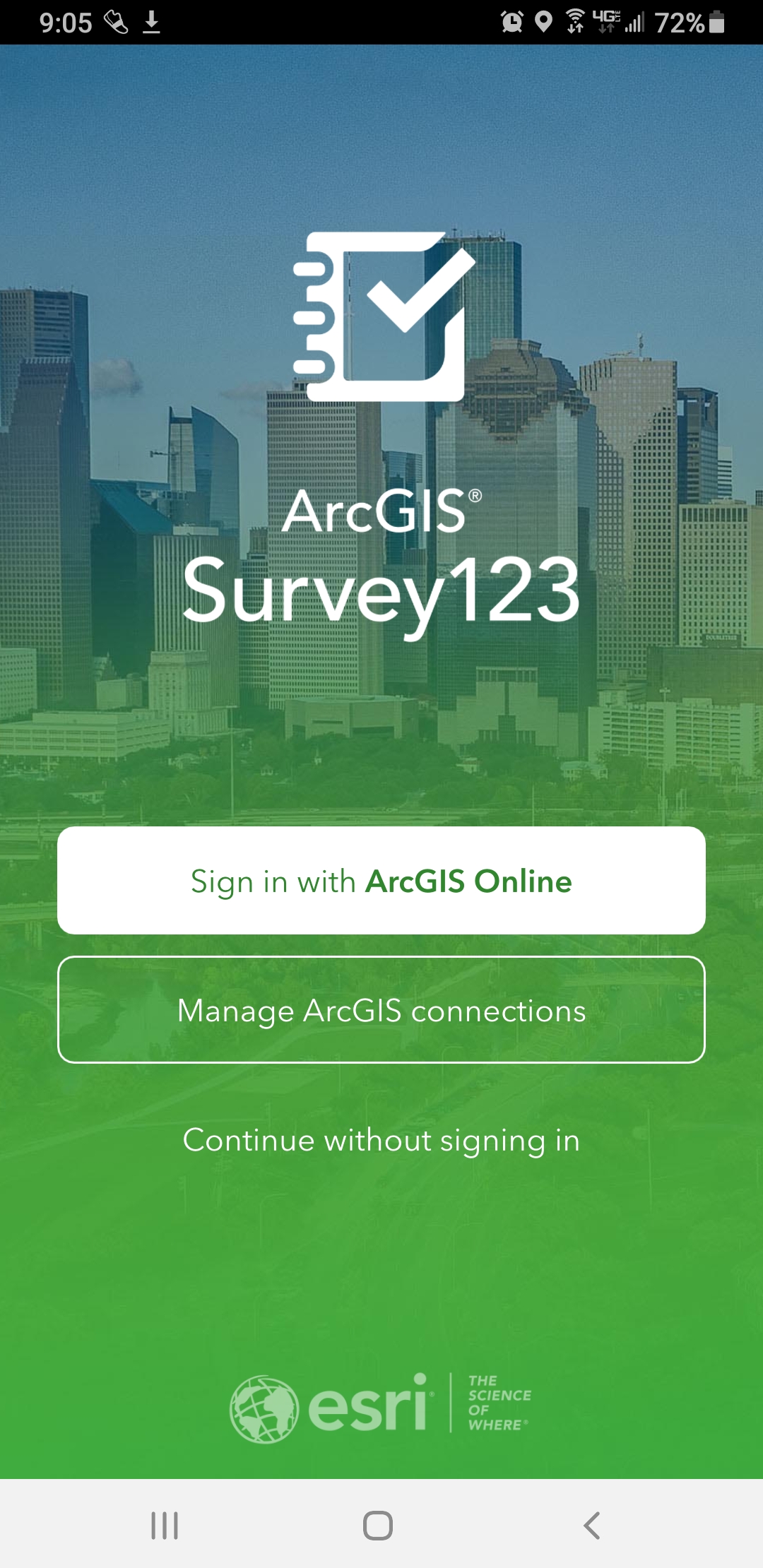
- Open the app. You will see a screen with the options to “sign in with ArcGIS Online” “Manage ArcGIS connections” and “Continue without signing in.” Select “Continue without signing in.” Note: You may log in with your ArcGIS Organization account username and password (free for all K-12 schools), BUT you are not required to log in to participate in the study.
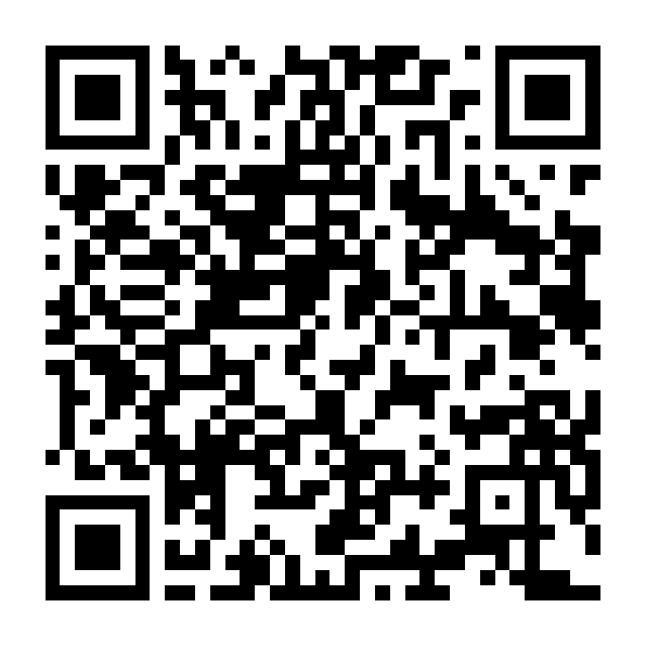
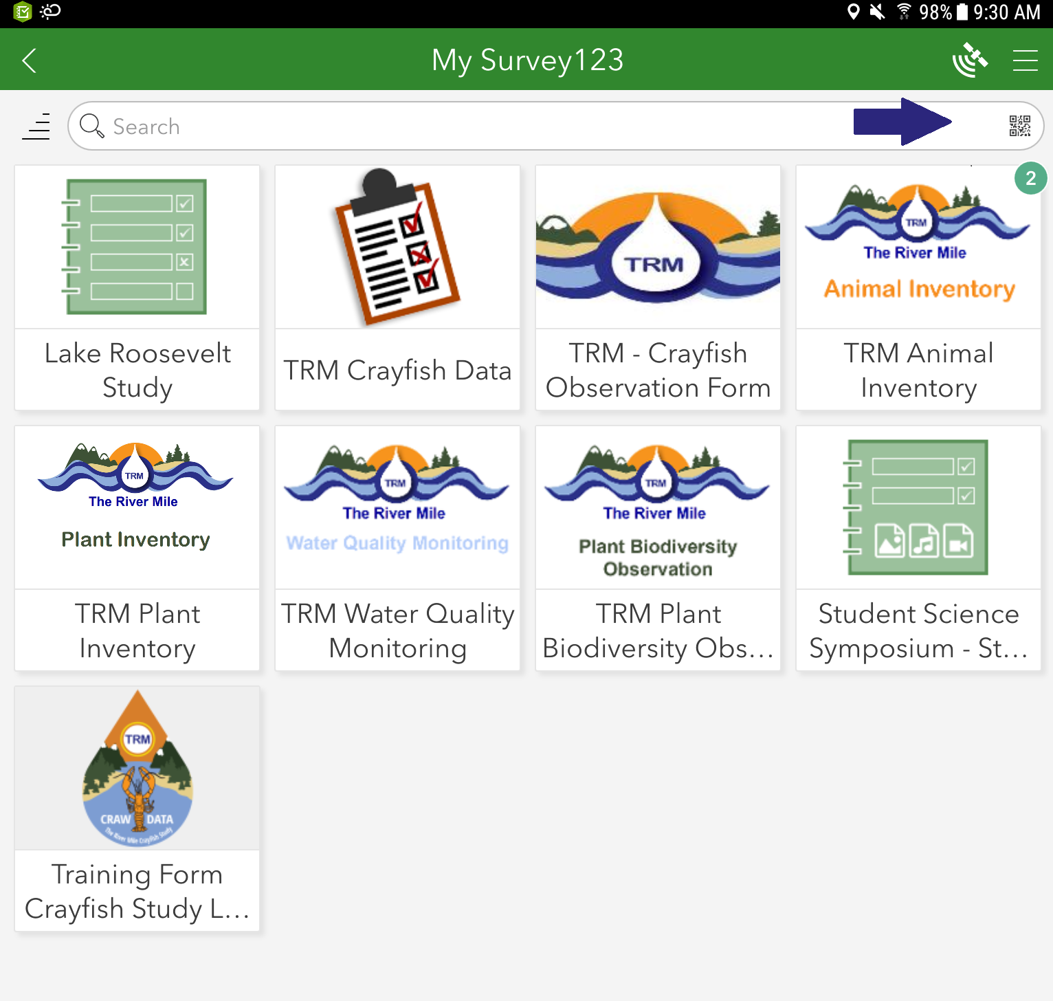
There are at least 2 ways to find the survey forms you want. One is to scan the QR Code for the survey, the other is to search using keywords.
- To scan the QR Code find the small QR Code symbol on the right in the search box, click or tap it and then scan the code for the form you wish to use. The blue arrow in the image points to the QR code in the search box.
- To search for the form you will need to be logged into an organization account, then you can download the form(s).
Links and QR Codes
Crayfish Study Short Form (online)
Once the Survey123 app and TRM forms are downloaded to the device, students will only need an internet connection to submit collected data to The River Mile database.
If smart devices are not available, students may use a digital camera to take site photos. Data may be written down by hand and input into Survey123 using a desktop computer. If you have any concerns about uploading the data to our database, please email therivermile@gmail.com.